Spring 2022
The first leg of this trip took us to Las Vegas then down US-95 to the Davis Dam. This Bureau of Reclamation power generating dam is next downstream from the Hoover Dam and is described as “a zoned earth-fill dam with a concrete spillway.” Nancy found this suspicious since the Corps of Engineers builds earthen dams, but it is a Bureau of Reclamation dam after all so we continued onward to Route 66.

Route 66 in California had been just about replaced by interstate highways when we came west in the early 70s but there seems to be a growing fascination with the route today and after seeing Disney’s version of the route at Cars Land, we wanted to see what was left of it. Also, the Route 66 Corridor Preservation Program is administered by the National Trails Office of the National Park Service so this qualifies as a National Park visit.
First, however, we had to fully justify our Certificates of Accomplishment from Arizona by visiting Oatman, Arizona, the last westward stop on Route 66 in the state.

We didn’t go through Oatman when we came west but neither did anyone else after it was bypassed in 1953. Today, it’s a tourist lure because the average resident there seems to be an ass. We had to see this for ourselves.
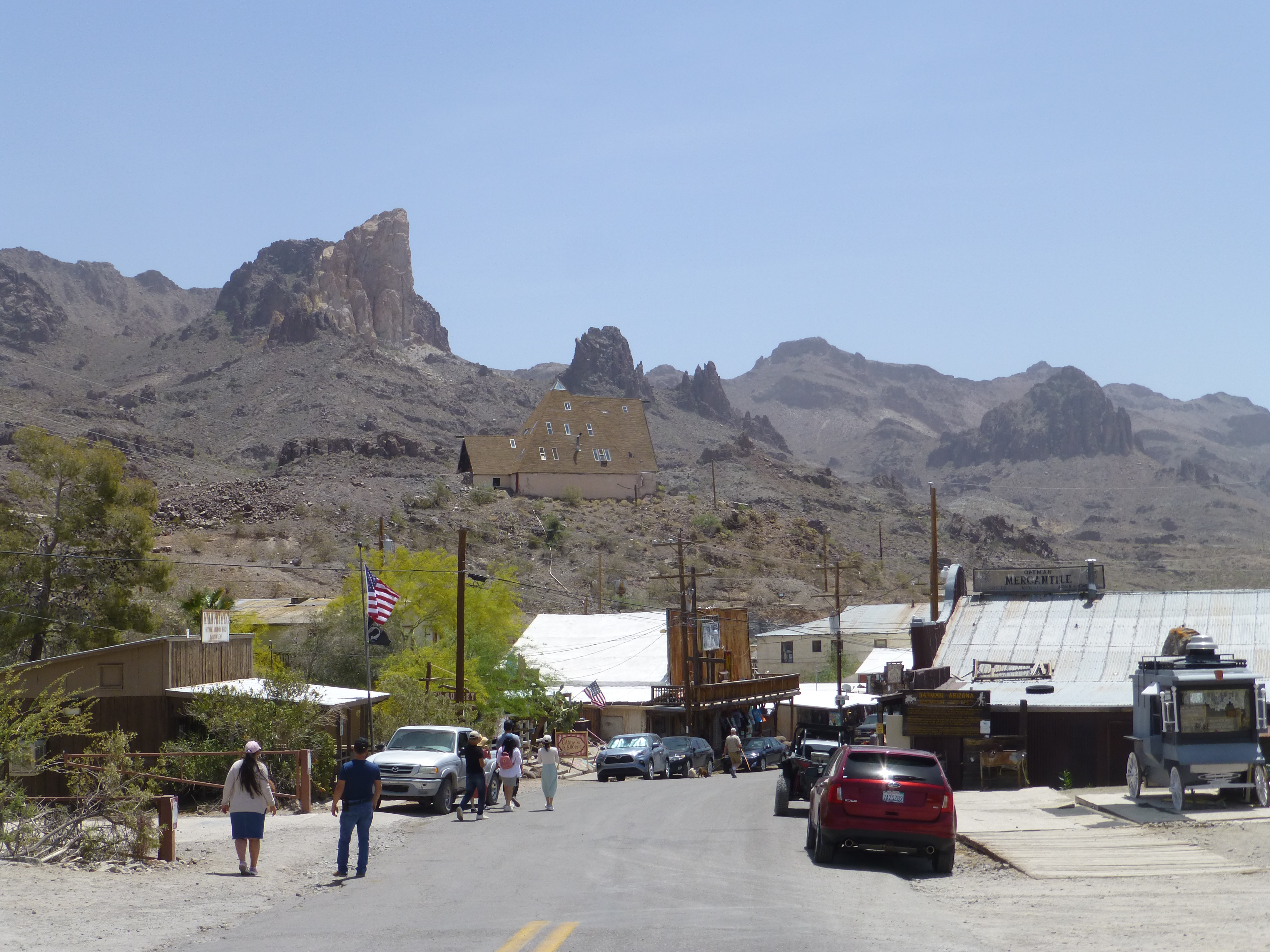


For those wondering: a burro, a donkey, a jackass, and an ordinary ass are all the same animal.
--------
We drove the desolate old Route 66 from Oatman to Topock where we joined I-40 and again crossed the Colorado River into California over the 1966 San Rafael Bridge. As we crossed we could see the historic Old Trails Bridge, famous in movies as the arch bridge that was Route 66 until 1948. PG&E saved it from demolition and today it’s a pipeline bridge.

The interstate follows the river into Needles where we exited to follow old Route 66. Time has not been kind to the historic route. Today, that section of town is a series of empty lots and abandoned buildings. Back on the freeway, we had to skip the Amboy Route 66 loop between Needles and Barstow since it was closed for bridge construction and things weren’t any better in Victorville where the historic route goes through one of the seedier sections of town.

I-40 replaced Route 66 into Barstow but the route from Barstow to San Bernardino is all I-15 so, at Victorville rather than continuing with the returning Las Vegas traffic, we took a side trip to Big Bear Lake. We visited Lake Arrowhead when we lived in southern California but we had never visited Big Bear before this. In addition, Nancy has been following the bald eagle cam there and wanted to stop by and say hello.
The lake is a popular summer resort and Bear Mountain is an equally popular ski resort. I thought it seemed a lot like South Lake Tahoe but Nancy disagrees.

We left the lake area on the Rim of the World Scenic Byway and then wound our way down to San Bernardino on State Route 18. When we got to San Bernardino, we were immediately reminded that times have changed.
The police had taped off an entire strip mall and we could see the forensic team collecting bullet casings from the street as medical examiner staff were working up by the buildings and news crews were filming from across the street (in case you’re wondering, the investigators had jackets that identified them and the news crews had cameras). The story of the shooting at a club party that left one dead and eight injured was the lead on the television news that evening.
We moved on and headed to Foothill Blvd and back in time to see what remains of Route 66. Our first destination was the border between San Bernardino and Rialto and the 1949 Wigwam Motel which is much like the one in Holbrook, Arizona.

Most of the guidebooks are sure that the 50s-style Motor Courts are a thing of the past and what’s left are just abandoned hulks, but that’s not the case at all. As we drove through Fontana we began to see dozens of newly refurbished--or at least rescued--strip-style motels. We saw the Fontana Motor Lodge, the Fontana Inn, Red Wing, Fiesta, Rex, Chemo, Sunset, and my personal favorite, the 40 Winks Motel. Apparently, there are--or were--40 Winks Motels all across the United States and there is one still in operation just a short distance from us on old US-395 in Reno.
The Foothill Blvd drive was fascinating. Each city on the way lets drivers know they are on Route 66 but none is as heavily branded as Rancho Cucamonga. Other cities have stenciled Route 66 highway signs on the roadway but Rancho Cucamonga also put pillars on the road dividers at every intersection and one overpass has 3D sculptures of classic cars on the roadway.


Many of the modern businesses along the way are also branded. But Route 66 Smog Shops and Route 66 Car Washes just seem so wrong especially when there are authentic Route 66 sites like the 1839 winery, the 1915 service station, and the 1955 Magic Lamp Restaurant.

At some point in Glendora, Foothill Blvd becomes simply Historic Route 66 which seems to end at the Monrovia city limit. We had to turn right and then left to continue on Foothill Blvd to the Aztec Hotel. This 1925 hotel is an example of Mayan Revival architecture and is currently being restored under the NPS Route 66 Preservation Program.

We continued on Foothill into Pasadena where Route 66 gets strange. From Pasadena to Santa Monica, there are multiple routes and multiple endpoints for the historic route. There are three different claimed endpoints: Broadway at 7th St in Los Angeles, Lincoln Blvd at Olympic Blvd in Santa Monica, and Colorado Blvd at the Pier.
We kept things simple by taking the 110, California’s first freeway, to the Santa Monica pier and the “End of the Trail” marker. This was an easy decision since we were staying at the Wyndam Santa Monica at the Pier.

We had heard that the Santa Monica Pier had a mixed reputation but we had a completely positive experience. The place was crowded but we expected that. We felt quite safe and there was obvious but unobtrusive security around and everyone was having a good time. All of our meals were excellent. Despite the rule that every waterfront locale must have a Bubba Gump’s, we didn’t eat there.
Our exercise for the morning after we arrived was the Ocean Front Walk south to Venice Beach. We had thought about going farther but turned around before we reached the recently re-opened Muscle Beach. There has been a major effort to move the homeless encampments from the actual beach, but the store fronts remain shuttered for the most part and the street vendors and the remaining homeless were a sad sight and a little depressing.
The return walk back along Santa Monica Beach was enjoyable and we did have the classic view of the pier to delight us.

We actually had very good weather while we were there. We’re quite familiar with California’s June Gloom--we tried camping on the Sonoma coast in June once, and only once--and we actually drove through the rising marine layer on our drive down from Big Bear Lake, but the complaints about May Gray aren’t really justified. The ocean fog lifted by noon while we were there and the temperatures were quite pleasant.
Finally, having completed our tour of Route 66, we started our journey home in the most southern California way possible: we braved the heavy traffic as we took the 10 to the 405 to I-5 to CA-14 to US-395. It was a harrowing experience but we survived it and managed to make it to Erich Schat’s Bakkery for lunch before heading home.
This was our first road trip since Covid (other than Tahoe of course) and we were extremely cautious. We had our second booster two weeks before we left and we wore our N-95 masks in all indoor locations as well as on the crowded pier. We ate at restaurants with al fresco dining for the most part and when we had to eat indoors, we selected secluded tables and wore our masks unless we were actually eating. Outdoor social distancing and hand sanitizers are a normal part of our regular routine and we kept that up.
All of this seems to have worked. We managed to avoid getting Covid and we’re declaring victory for this trip. Good times.