Arches NP, Canyonlands NP, Capitol Reef NP

Summer 2012
Arches National Park
This is the home of sandstone spires and fins and monoliths and over 2,000 cataloged arches. A drive through the park presents one fantastical structure after another with many descriptively named:  Double Arch, Balanced Rock, Three Gossips, Courthouse, Elephant Butte and the Tower of Babel. But what surprised me was how many of the best-known features require an often significant effort for anyone to see them. Our pedometers were spinning on this trip.

Even the iconic Delicate Arch, symbol of Arches and currently pictured on Utah license plates, is in a remote section of the park and the trailhead for the arch's 3 mile hike warns that each person should carry a minimum of a quart of water just for that hike alone. There are also two trails that lead to viewing areas. The shorter of the two, which is wheelchair accessible, provides a mile distant view of a tiny arch. The other viewing trail is a half mile hike up a rocky path leading to a further scrabble up to a slickrock ridge, but it does provide great views of the world's most famous arch.

------------------------------------
Canyonlands National Park
The Island in the Sky section of Canyonlands is a massive mesa that sits two giant steps above the Green and Colorado Rivers.  The White Rim, which sits 1200 feet below the mesa, has been intricately eroded another 1000 feet by the rivers. The White Rim Road, visible from many of the overlooks, makes a complete circuit of the rim that takes a minimum of two days by off-road vehicle.
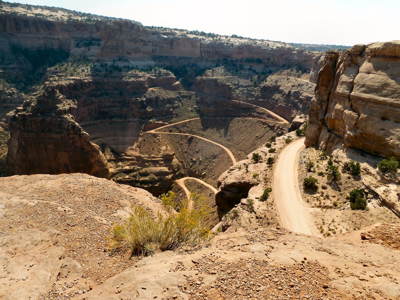
Shafer Trail to White Rim Road
Normal visibility at Canyonlands is 100 miles south and the point at which the Green and Colorado Rivers converge can usually be seen from Grand View Point Overlook, but we weren't able to make it out. The West is burning and northerly winds are blowing heavy smoke into southern Utah filling the canyons. Nevertheless, the views were still stunning.
Green River at Canyonlands

Due to the smoke accumulation in The Needles section of the park, we decided not to visit and The Maze section of the park is one the most inaccessible places in the United States and we never had any intention of visiting there.

-----------------------------------
Capitol Reef National Park
The primary purpose of this park is to protect the Waterpocket Fold, a monocline, described as a major wrinkle in the earth. It's quite dramatic when viewed from the ground, but with a length of a hundred miles, only aerial views show how impressive it truly is. The National Park Service should provide airplane rides, but only provides photographs.

NPS Photograph of Waterpocket Fold
Early American explorers thought that the white domes of the area resembled the U.S. Capitol Building and that the Waterpocket Fold acted like a barrier reef to their wagons, thus giving us the name for Capitol Reef National Park.

Capitol Dome behind Waterpocket Fold
It's a little difficult to appreciate the scope of the monocline looking up at it from the west side, but it is easy to see how hard it would be to cross. Fortunately, the Fremont River cuts through the fold and the area has had human inhabitants as far back as the Ancient Puebloan culture which left wall carvings. Later, the Mormon pioneers established the Fruita settlement, planting orchards still maintained by the National Park Service today. Visitors can sample apples, peaches and pears during harvest season and we enjoyed the apple pie baked at the historic Gifford Homestead in the park.

------------------
Other Things
Moab, UT
Moab may be a funky mountain town but it is easily the most cosmopolitan place in Utah. Every shop and restaurant was filled with people speaking German, French and Italian and they certainly outnumbered the American tourists.

Utah Highway 24
With Moab as our base, we entered Capitol Reef National Park from the east side by way of  Highway 24 from Hanksville. As we drove down the road, the terrain became so strange and so different from anything I had ever seen before that I began to think I might actually be driving on a highway on some distant planet. I took photographs during the return trip (see link below) and these give some idea of what I mean, but the back trail was just different enough that it lost a little bit of that other-worldly flavor

The Wasatch Range
Fall comes early in the Wasatch Range. The Canyon Maple were full red as we drove Utah 6 , but, again, the smoke really made it far less enjoyable than it might have been.

For Additional Photos, click below:

Crater Lake NP and Lava Beds NM

Summer 2012

CRATER LAKE NATIONAL PARK
I thought Crater Lake would be Lake Tahoe without the lakefront mansions or the highrise casinos, but other than the clarity of the water, they don't have much in common. Rim Road circles Crater Lake at about 500 to 1000 feet above the lake surface and the slope of the caldera wall makes access to the lake nearly impossible. In no way can Crater Lake be considered a recreational lake.

The only route to lake level is the Cleetwood Cove trail which is rated as one of the park's more strenuous hikes. It's said to be the equivalent of 65 flights of stairs and locals joke that the trail is one mile down to the water and 12 miles back up to the rim. Only at the bottom of the trail can visitors swim (it's very cold), fish (stocked in the late 1800's), or get onto the lake in one of the tour boats (originally brought in by helicopter).

After our own hike and tour we were glad we had a room nearby at the Crater Lake Lodge. This historic hotel has only 71 rooms and perches on the rim of the crater. Our room was an oddly shaped thing but it certainly had a spectacular view.

View from Lodge Room

The lake is a dark blue color due to its depth and the clarity of the water. The water simply absorbs every other color. The only sources of water for the lake are rain and snow and we were told that the water is pure enough to be considered distilled.

The large island in the lake is Wizard Island which is actually a volcano inside the volcano. There is another volcano in the lake, Merriam Cone, but it never grew large enough to break the surface. This gives you some idea of the size of Crater Lake and, in fact, before its eruption and collapse, Mt. Mazama was the highest and largest mountain in what is now Oregon.

On our boat tour, we visited the other island in the lake, the Phantom Ship. While Wizard Island is the youngest volcanic feature of the park, the Phantom Ship is the oldest. Given the size of the lake, the Phantom Ship looks small, but looks can be deceiving. The island is 500 feet long and 16 stories at its highest point.

The Phantom Ship
The park now offers a Ranger-led trolley tour along Rim Drive and that was really well done. We circled the lake, stopping at key overlooks, and got a good explanation of the geology and history of the lake. 

Crater Lake Trolley

What I found most surprising was that, in geologic time, the crater was created just yesterday. Eruptions in the Cascade range go back 30,000 years and as recently as Mt. Lassen and Mt. St. Helen in the 20th century, but it's astonishing that Crater Lake was created just 7,000 years ago and that archeological finds of sandals covered with Mt. Mazama ash, as well as native stories passed down through hundreds of generations, indicate that humans inhabited the area during this cataclysmic event.

Crater Lake is an amazing place where the clarity of the water is matched by the clarity of the air. We live just down the road from UNR's astronomical observatory and are used to clear nights thanks to our afternoon zephyrs and the dark sky initiative, but Crater Lake has a night sky that seems close enough to touch. There is a famous photograph of the Milky Way over Crater Lake and, earlier this year, solar flare activity resulted in a rare photograph of the Aurora Borealis over Crater Lake. Sunrise and sunset are nearly as impressive.

Caldera Sunrise

LAVA BEDS NATIONAL MONUMENT
Tucked into the nearly inaccessible northeast corner of California, the lava beds were created by lava flows from the numerous shield volcanoes in the area. It is an other-worldly place most famous for its lava tube caves. There are 20 open to public exploration and 200 more serving as home to 40 species of bats and other creatures. They vary in size with some as large as traffic tunnels.

The Devil's Homestead

Beyond the natural environment, the area is home to two historical sites that tell interesting, and largely forgotten, stories from our history. The Modoc Indian war was fought here in 1872-1873. Even contemporary accounts saw this as the romantic adventure of Captain Jack and his band of 52 Modocs holding off a US Army force 8 times their number and armed with artillery. But, when it was all over, it was merely a tragedy on both sides that only highlighted the folly of President Grant's Indian policy that forced native peoples together onto reservations without regard to the enmity between the different tribes.

Lava Beds is also home to the Tule Lake internment camp from World War II. This camp became the site for the so-called "No-No" trouble-makers and it soon had the largest population of all ten camps despite the fact that no Japanese-American was ever found to have committed any treasonous act. Today there are only remnants of the camp left as it was systematically dismantled after the war. (You might think it was out of embarrassment, but they simply wanted to get the camp materials into the post-war supply chain.)

Finally, the area is also home to the Tule Lake National Wildlife Refuge, a major stop on the western migration route of waterfall and other birds and famous for its Bald Eagle population.

For Additional Photos, 
Go To:

Yosemite and Sequoia-Kings Canyon National Parks

Spring 2012

With so many National Parks still to visit, we really don't have time for repeats, but a new car calls for another road trip and there's nowhere better for a road trip than Yosemite Valley.

  • Yosemite NP 
I regret not having been able to visit Yosemite before 1970 when it really was a different place--bear feedings, firefalls, and drive-through trees just for starters--but, still, I have lost track of how many times we have visited since we first came to California. I do know that we have been there in every season and just about every month of the year. 


We've been to the Bracebridge Dinner at the Ahwahnee Hotel on Christmas Day, skated at Camp Curry, and checked out the downhill ski conditions at Badger Pass. We've seen massive waterfalls during spring runoffs and spectacular fall color on the valley floor. We've seen the sun rise over Half Dome and then hiked through the mists to the top of Vernal Fall and on to the top of Nevada Falls to get out of the summer heat.


We've worked our way through every form of sleeping accommodation from a tent in the old Lower River campground to Tent Cabins at Curry Village to a real cabin at the Yosemite Lodge to a room at the Lodge and even to a room on the third floor of the Ahwahnee Hotel itself.

Based on all this experience, I can say with absolute certainty, that the best time to visit Yosemite is simply as soon as possible. No matter how bad the weather is or how crowded the park gets, once you're there, you can stop at any time and look up in any direction from the valley floor and fully realize that you are in the single most beautiful place in all the world.

  • Sequoia NP
Sequoia was the second National Park after Yellowstone and had the primary mission of protecting the sequoia trees of the Giant Forest.


Unlike their cousins the coastal redwoods, which seem to grow skyward forever, the giant sequoias quickly grow to their full height of just under 300 feet and then start adding thickness. The General Sherman tree in the Giant Forest has been doing it best, and until the recent discovery of that bizarre fungus in Oregon, it was considered the largest living thing on earth. By one count, there are 34 other groves of sequoia in the park, but the Giant Forest is home to five of the ten most massive trees in the world as well as dozens more.
  • Kings Canyon NP
Less than a month after the establishment of Sequoia National Park, legislation was passed establishing Yosemite National Park. Included as part of this legislation was the establishment of General Grant National Park which was nothing more than the Grant Grove of giant sequoias. Then in 1940, Kings Canyon National Park was established to protect the deepest gorge in the United States where the forks of the Kings River converge and General Grant National Park was made a part of this new park despite being nowhere near the gorge. And today, Sequoia and Kings Canyon are administered as if they were one park. The whole story of the establishment of these three (or four) national parks in the central Sierras is really quite murky and confusing, but they are certainly fine jewels of the park system.


Most people visit Kings Canyon National Park to see America's Christmas Tree, the General Grant giant sequoia, and most never make the long trek to visit Kings Canyon. It's very much like taking Tioga Road to Tuolumne Meadows in Yosemite: those who make the additional effort are well rewarded.

  • Yosemite Mountain Sugar Pine Railroad
OK, the truth comes out. The real reason for this trip was to visit the Ansel Adams Gallery to pick up a special print and most especially to ride the Sugar Pine Railroad. As the name suggests, the railroad was in the lumber business, specializing in harvesting the sugar pine tree.


The Great Depression hurt the lumber business badly and in 1931, after a very successful 56 year run, the owners shut down operations. It's only been in recent years that it was revived with steam train rides for nostalgic tourists. In many ways it reminded me of the Sugar Cane train on Maui.

The Yosemite Mountain operation is just outside the south entrance to Yosemite National Park and, after our morning train excursion, we headed for the Wawona Hotel for a great lunch on the hotel verandah.

For Additional Photos, Go To:
Also, I hope to soon add a link to more pictures as I scan our best 
Yosemite slides from over 30 years of visiting this National Park.

Joshua Tree NP

Spring 2012 

The Joshua Tree isn't a tree and only a vivid imagination would see these yucca plants as the biblical figure with his arms raised to heaven, but, there's no doubt they are an amazing feature in an extraordinary place.


The National Park is about evenly divided between the Colorado Desert and the Mojave Desert and we entered the park from the Palm Springs side which is in the Colorado Desert.  This is California's Low Desert and the Joshua Tree doesn't grow there, but, because of recent rains, we did get to experience a desert in bloom. There were red blossoms on the ocotillo and beavertail cactus and yellow blossoms on the brittlebush and the cholla cactus. Water run-off collected on the side of the road where dune primrose had large white flowers and, in a few areas, tiny, yellow wildflowers still carpeted the desert floor. The Cholla Cactus Garden area was especially dramatic with tiny cactus blossoms everywhere.


And this abundance brought out the wildlife.  Roadrunners and jackrabbits scurried across the road in front of us and zebratail lizards paid us no mind as they feasted and we took pictures. At Cottonwood Springs, birds, including darting hummingbirds, noisily went about their business.

The springs are not technically an oasis since the cottonwoods and palms were planted by prospectors and miners in the area, but at least there is the water to support one.  On the other hand, the Oasis of Mara, at the northern entrance, was an actual oasis until the water dried up. Now the Park Service waters it mechanically to keep it alive.

A gradual climb into the Mojave's high desert brought us to the Joshua Trees and strange rock formations. The granite stacks are a result of chemical weathering and are quite popular with rock climbers. We saw remnants of mining operations at Lost Horse Mine and we entered Louis L'Amour country in Hidden Valley, a natural corral where cattle rustlers hid out near the Keys Ranch.


If the change from one desert to another was subtle in the park, it became very noticeable after we exited at Twentynine Palms. The Morongo Valley leads to a rapid descent from the High Desert to the Low Desert through the San Gorgonio Pass. As we curved into the Low Desert's Coachella Valley below the cloud level, we could feel the strong wind funneled from the coast. This is the site of one of the three major wind farms in California and we drove through mile after mile of these giants as we returned to the Palm Springs area.

I had been a little disappointed that the tours of the Keys Ranch in the park had already ended for the season because their story is apparently a true life western with a working wild west ranch that operated into the early '40s. But, what makes this more interesting is that, in Palm Springs, major changes to living in the desert were beginning just as this way of life was ending.

Palm Springs' Desert Modern Architecture
For those of us with deep roots in Pittsburgh, the Kaufmann name simply recalls the great department store, but Edgar J. Kaufmann is world famous for commissioning not one, but two of the greatest examples of modern architecture. Fallingwater, designed by Frank Lloyd Wright, is probably the best known private residence in the world, but the Kaufmann Desert House, designed by Richard Neutra in 1947, while not nearly as famous, was far more influential, providing much of the inspiration for the development of what came to be called Desert Modern architecture.


It certainly wasn't the first of the Desert Modern style:  Neutra himself had designed the Grace Miller House in 1937, but after Life magazine featured Julius Shulman's iconic photograph of the house in its April 11, 1949 edition, the architectural world took notice and the '50s and early '60s saw a major effort to provide gracious living in a harsh environment.

Today, of course, we build stucco boxes and slap on air conditioners, but Palm Springs remains the center of the Desert Modern style and the Kaufmann House continues to be occupied as a private residence. The style probably reached its peak with Frey House II, designed by Albert Frey in 1962 on the hillside above Palm Springs, where the owners most likely can see the Kaufmann House.  (For a fascinating article about Neutra, Wright and the Kaufmann House, see Glamourized House).

The Anti-National Park
Just south of Joshua Tree National Park is the Salton Sea, certainly one of the strangest places on earth. When spring floods broke through the dikes in 1905, the full force of the Colorado River flowed uncontrolled into the Salton Sink for two years creating California's largest fresh-water lake with a "sea level" that was 200 feet below sea level. This soon became an inland playground for the rich and famous, touted as the American Riviera.

In the early '60s, however, the fresh-water sources were diverted leaving only agricultural run-off and water from the worlds' most polluted river, the New River flowing from Mexicali, to replace the evaporating water of the Salton Sea. The result, then, was California's largest salt-water lake with high levels of selenium and recurrent algal blooms. The subsequent loss of thousands of fish and birds gives fair warning and abandoned buildings and derelict boats tell their own story. We didn't stay very long.

Southwest of the Salton Sea, the Cuyamaca Rancho State Park is just as disturbing.  In 2003, a lost hunter set a signal fire that grew into the Cedar Fire, the largest wildfire in California history. The fire burned over a quarter million acres and was so intense that, almost nine years later, there is very little natural regeneration. As we drove through the park, each new ridge had the skeletons of hundreds of dead broadleaf trees, standing with blackened branches in a truly post-apocalyptic landscape.

U.S. 395
On a brighter note, we continued our exploration of U.S. 395 back where our California adventure began.  Today, 395 officially ends at Hesperia in San Bernardino County, but the route still exists as I-215 and I-15 and remnants of the old route can still be found. Unfortunately, in Riverside, just before March AFB (now ARB), the frontage road that we knew is no longer called Old 395 but Old 215. Now that's a shame.  But just south of Temecula, there is an exit to the frontage road and it, at least, is still called Old 395.

We returned to Temecula where we last visited when the vineyards first started producing and things have gone well. But Old Town Temecula was the highlight this time:


For more pictures, go to:

Saguaro National Park

Winter 2012

If it's not going to snow this winter, there's no reason for us to put up with the cold. So we headed south for Arizona and the Sonoran Desert.

Saguaro National Park is named after the giant cactus that grows only in this desert. If you were to draw a picture of a cactus, that's the one you'd draw. You'd probably have arms on either side but most have no arms at all but are simply columns.


The desert and the saguaro (suh-wah-rho) cover most of southern Arizona and I was a little surprised with what we saw inside the national park. I expected thick forests of giant cacti but these weren't quite that. In fact, we saw individual specimens on Cactus Road in Scottsdale that simply dwarfed anything we saw in the park and while there were large groups, they seemed a little sparse.

Well, it turns out that there is an interesting explanation for this. When the park was designated a National Monument in 1933, there were, in fact, massive forests of giant saguaro. Photographs show the size and extent. But, almost immediately, a lingering freeze hit the area and the saguaro began to quickly die off. Then, for thirty years the area recovered only to be hit by another lingering freeze in 1962 with the same result. So, most of the saguaro here date only from the early sixties. The two districts were designated a National Park in 1994 and I really have to say that the timing of that really seems to be tempting fate.

We saw a small group of javalinas, those distant cousins of hogs and boars, rooting around outside the Visitors' Center. They are apparently quite common throughout the area. We didn't see much of anything else, but that may be best since the Sonoran Desert is home to some of the world's most infamous creatures including diamondback rattlesnakes, gila monsters, black widow spiders, coral snakes, scorpions and tarantulas. We stayed on the paved trails.

Taliesan West
We couldn't go to Arizona and not visit Frank Lloyd Wright's winter home. We toured Fallingwater while we were still dating forty-some years ago and have been Wright fans ever since, visiting many of his projects in northern and southern California.


His actual living quarters are really quite spartan and it's obvious that he lived for his work. Besides being his personal residence, Taliesan West was also a campus for his architectural school (he needed the money) and a laboratory for architectural experiments. The school is still in operation as an accredited institution and the results of some of the experiments, both successful and not, are quite evident on the site. His use of (perhaps invention of) hidden/recessed lighting is quite innovative and night tours are offered to see the full effect. However, his extensive use of redwood in this desert climate merely resulted in dry rot.

Spring Training
Things have changed a bit since the days when spring training actually took place in the spring. Now, of course, spring training is a winter event and the first day of spring means opening day is almost here.

The Cactus League has grown considerably and a number of teams have to share a ballpark. The Giants have their own in Scottsdale and that's where we headed. I thought tickets for good seats were a little over-priced and hard-to-get, but all was forgiven when we got to Scottsdale Stadium. The grass was green, the trees were in full bloom and the Giants and Rockies were going to play a baseball game.


The fans were in a great mood. Although most were from the Bay Area or Denver, there were fans from all over the country and everyone was asking, "Where you from?" and "How long are you here for?" It was mostly an older crowd and Nancy noticed how everything became real quiet around the sixth inning. Even the grandchildren were quiet as the grandparents, after a few beers in the warm sun, weren't quite able to make it to the seventh inning stretch and perhaps nodded off just a little.

The game itself was just an exhibition game, but that didn't keep us from rooting for a win. After trailing from the third pitch of the game, the Giants mounted a furious come-back in the bottom of the eighth to pull out a victory. Giants fans left happy and headed for the bars and restaurants of Old Town Scottsdale. It was great fun.

For more pictures, click on the link below: