CHRISTMAS ADVENTURE 2017

December 2017
 
My favorite Christmas Adventure will always be the Bracebridge Dinner we attended at the Ahwahnee Hotel. This dinner has been a Yosemite tradition since 1927 when Ansel Adams and friends put on their first amateur production of the Washington Irving story. When we went it was still a single Christmas day dinner with tickets distributed by lottery. Native Californians couldn't believe we got in on our first try.

The dinner was great fun and, in addition, we skated under the stars at Curry Village, visited the Badger Pass Ski Area on the road to Glacier Point, and sang Happy Birthday to Jesus at the Yosemite Chapel with birthday cake afterwards.

Most of our adventures, though, have involved the sights and sounds of San Francisco's hotels and department stores and skiing on Christmas day at Bear Valley with friends.


This year we decided it was time for another warm-weather trip and we headed for Las Vegas, Palm Desert, Newport Beach, and Disneyland. 


LAS VEGAS

We spent most of our Las Vegas time at the Venetian which had great entertainment and dining in their re-creation of St. Mark's Square, but we were disappointed to see the half-hearted attempts at Christmas decorations there and in most of the other casinos we visited.  


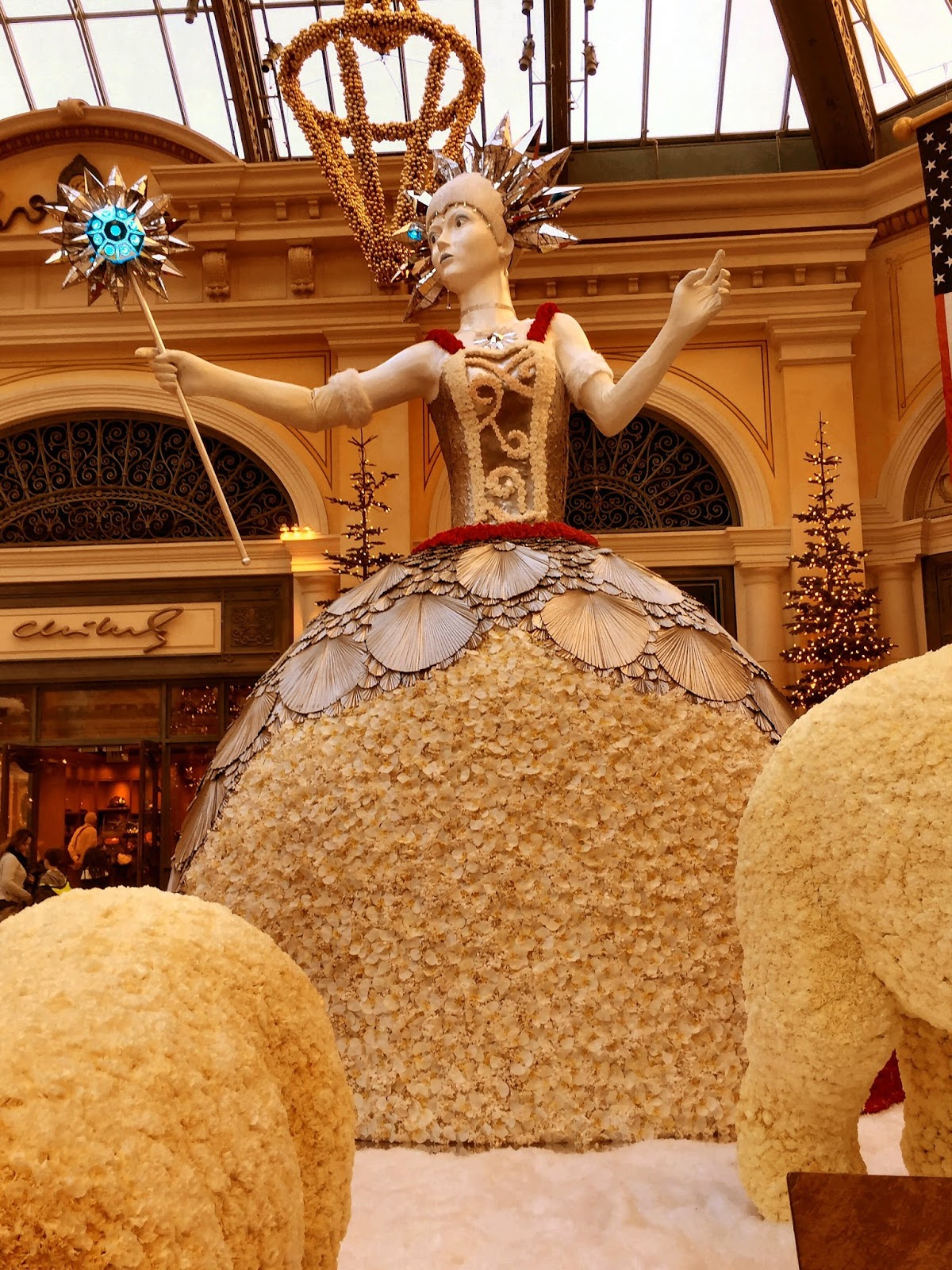
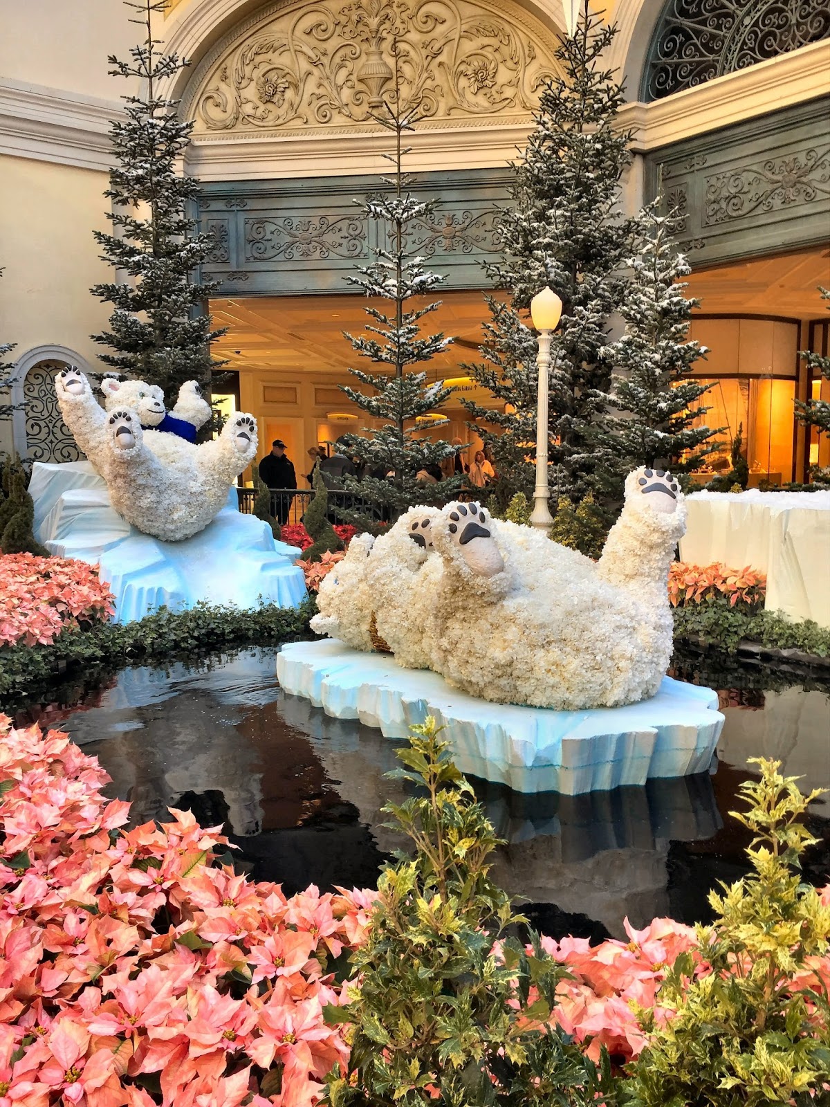
Fortunately, we knew we could count on the Bellagio Conservatory. 


The Bellagio's Holiday Glamour presentation included a 42 foot White Fir from Mt. Shasta and an 18 foot Ice Princess, as well as a garden railroad, 14 foot toy soldiers, and white carnation polar bears on ice at the North Pole train station.


 ______

While in Las Vegas we made a trip to Lake Mead (which qualifies this trip for a National Park visit) and found it to be still depressingly low despite last year's great snow season.


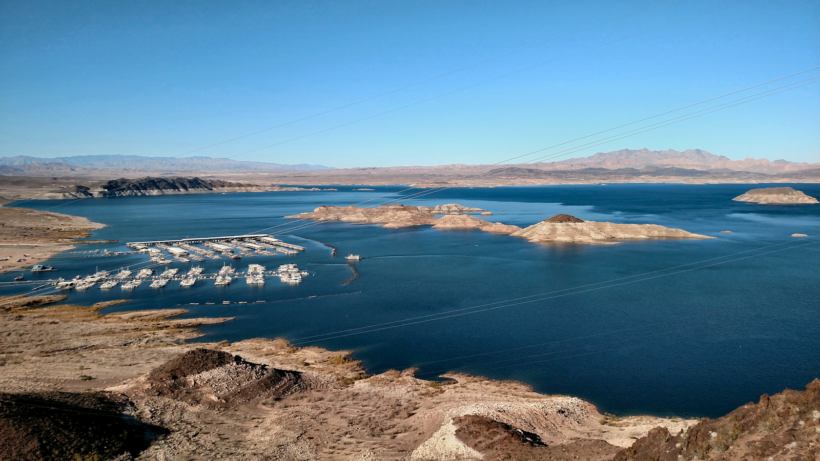
But the reward for this visit was when we discovered that wild horses on your lawn are easily matched by bighorn sheep in your backyard.

One neighborhood in Boulder City is home to at least the two groups of bighorn sheep that we saw and I can now honestly say that I have seen far more bighorn sheep in Nevada than anywhere else in the country.


PALM DESERT
We next headed for Palm Desert and the Wildlights presentation at the Living Desert. This is an evening program of of over 1 million Christmas lights that allowed us to see the nocturnal animals in action. Unfortunately, the other animals simply seemed to be annoyed with the crowds that were keeping them from their sleep.

The giraffes didn't know what to make of us and stayed behind a hill with only their necks and heads above the horizon watching us carefully.

The wild dogs raced around their compound watching all of the small children very carefully. I think a number of the parents were oblivious to the implication.

Surprisingly, most of the smaller members of the cat family were curled up sleeping and tried to ignore us.

The G-Scale railroad was decorated for Christmas and a half-dozen trains ran their routes over the 3300 feet of rail so there was always something marvelous to see.

For the kids there were camel rides and reindeer feedings. The reindeer being fed were on the small size, no bigger than a pony, and well-qualified to be some of Santa's "eight tiny reindeer."


The weather in the desert was warm and the high school baseball teams staying at our hotel for a local tournament were already in spring form. And on Saturday, we visited the outdoor market at the College of the Desert where the parking lot was full of cars with license plates from all over the United States and Canada. 

Even with all of the National Parks we've visited, I've never before seen such a wide variety of different states' plates in one place. I know the Coachella Valley is a popular winter destination but this just seemed exceedingly odd.

Later, we ate lunch at an outdoor cafe and watched the kids on the skating rink in near 80-degree temperatures and then we knew we were in California, for sure.


NEWPORT BEACH
"From the Desert to the Sea ..." was how Jerry Dunphy opened his TV news segment when we lived in Southern California and that's what we did on this trip, driving from Palm Desert to West Newport Beach. The tide was going out when we got there and the few remaining surfers were packing their boards on the ingenious racks that balanced the boards on their bicycles before riding away.

We then drove over to the Fashion Island Mall.

We last visited there in the early '70s when J.C. Penney was one of the anchor stores and a Michael's-type craft store was the reason we went. Today, the mall is one of the more upscale shopping centers in the country with anchors including Bloomingdale's, Neiman Marcus, and Nordstrom as well as upscale car dealerships like Tesla and Bentley.

Quite a change, but we were back for the Christmas decorations and we weren't disappointed. All of the mall was well-decorated and I was especially impressed with the Neiman-Marcus displays.

The highlight for us at the mall was the simple lunch we had at Bloomingdale's "59th and Lex." The holiday setting at a department store cafe was so reminiscent of the good times we had Christmas shopping in downtown Pittsburgh with lunch at Kaufmann's or Gimbel's cafes (or Horne's, according to Nancy, but I refuse to remember a "Tea Room").

The main Christmas tree at the mall was a bit perplexing. The signage indicated that, like the Bellagio's, this was a white fir from Mt. Shasta and it certainly was fully 90 feet tall as described. But, when I looked up close, the branches I could reach certainly seemed to be artificial. Then I peered under the tree and could see that it was indeed real. I didn't know what to make of this so to the internet I went.


And there I found the answer. As you can see from the picture, this was not exactly a perfect specimen of a tree and in true Southern California fashion, a little plastic surgery was just the thing to take care of a few minor imperfections.

DISNEYLAND
We've been to "Mickey's Very Merry Christmas Party" in Florida which was great fun and I was afraid that this Disneyland visit would be somewhat of a letdown. But I was wrong. It could hardly have gone any better or been more fun.


© Disney

We know some of the tricks and we were able to visit everything we wanted to see with only short waits. We saw both Jacks: Jack Sparrow was hiding all through The Pirates of the Caribbean and Jack Skellington had completely taken over The Haunted Mansion.

We watched the Christmas Parade with all of the Disney characters, dancing reindeer and Santa Claus himself. (This is the Disneyland parade that was recorded during its first week and broadcast by ABC on Christmas day.) Then, in the evening, we watched as Sleeping Beauty's Castle was "Frozen" as snow fell on Main Street. Great fun.


© Disney
____________________

California Adventure has always been the poor step-child in Anaheim but change is in the air. 

Soarin' used to be the main, and perhaps only true, attraction and I'm not even sure Soarin' Over the World is any improvement over Soarin' Over California.

The other California Adventure attractions have always been quite forgettable, but then we discovered the town of Radiator Springs in Cars Land.

The Pixar film, Cars, has been brought to life there with dining at the Cozy Cone Motel and Flo's V-8 Cafe and interesting attractions starring Luigi and Mater as just some of the highlights of this new land and the town was fully decorated for Christmas. 


A Decorated Tire Pile

But, of course, it would be merely entertaining except for the Radiator Springs Racers.

This full-size slot car ride is now my favorite Disney attraction and the only one that required a serious wait in line. (We were too late to get FastPasses and I have read since that the wait in line for FastPasses is longer than for most attractions and that they run out quickly since people line up even before the Park officially opens!)


The ride itself is a third-generation version of Test Track at Epcot and has been totally transformed for Cars Land.


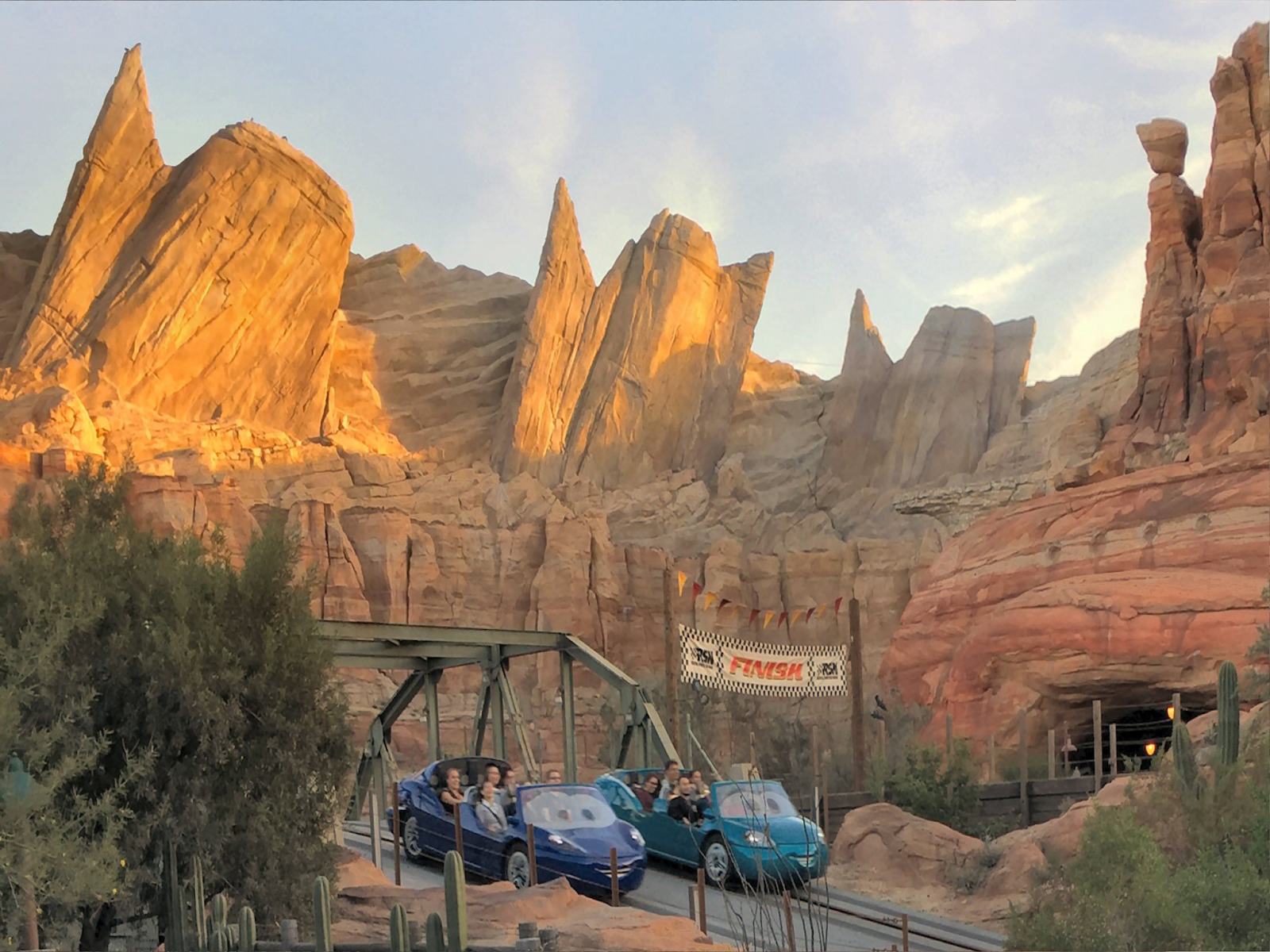
The ride starts with a day-time tour through Ornament Valley (which is right out of the movie, including Columbia River's Multnomah Falls transported to the desert!). Then you arrive in Radiator Springs at night where you have a lively encounter with most of the characters from the movie.

But all of this is merely prelude. At this point your vehicle is prepared for the big two-car race through the desert.

The cars bolt from the start and follow a course that includes road dips and tight curves to the finish line at the entrance to Taillight Caverns. Then you ride through the cave and on to the Cavern Visitors' Center and the end of the ride.

It's a full and exhilarating experience and it's hard to believe that the actual ride time is less than 5 minutes. This was easily the highlight of our visit.


DRIVING HOME FROM SOUTHERN CALIFORNIA
The drive from Anaheim to Reno (except Victorville to Ridgecrest) was a pleasant drive under a bright winter sun with blue western skies (once we were out of the basin).

We had planned this trip carefully to avoid the worst of the traffic. We drove into Orange County on a Sunday afternoon and although we departed on a weekday morning, we expected to be going against commuter traffic most of the way. And then we discovered that the carpool lanes were hardly used and this made the freeway drive from Anaheim to Victorville a simple matter.

At Victorville, we exited to US 395 North and took it all the way home. We had never before driven on this section of our favorite road and we may not again. From Victorville to Ridgecrest the road is an undulating two-lane blacktop full of trucks. The landscape is barren and there are few places to stop on the way.

Thankfully, at Ridgecrest, US 395 merges with CA 14 and becomes a multi-lane road for a lot of the way north. We passed the turn-offs for Death Valley and Mt Whitney, stopping for lunch at Erich Shat's Bakkery in Bishop before the ascent to Mammoth Lakes.

If we had lived in Southern California this might have been our Christmas ski trip drive; instead, we continued north to the Nevada border and then safely home. 


For a few more photos, go to:


50th HS Reunion - Epilogue

Here is an outline and a map of the entire trip:

  1. 50th HS Reunion - Part 1 - Reno to Pittsburgh
  2. Yellowstone National Park, Part 2
  3. Devils Tower National Monument
  4. Badlands National Park
  5. 50th HS Reunion - Part 2 - Pittsburgh to Reno
  6. Shenandoah National Park
  7. Blue Ridge Parkway
  8. Great Smoky Mountains National Park
  9. Great Sand Dunes National Park
  10. Black Canyon of the Gunnison National Park
  11. Arches National Park Encore
  12. Natural Bridges and Cedar Breaks National Monuments
  13. 50th HS Reunion - Epilogue


  14. - - - - -

    If you came here first, you are at the end of this particular journey. You can click HERE to go to the beginning. Or you can use the sidebar or the outline above to select the part you want to see. 

    - - - - -
    We were very fortunate on this trip and things went exceptionally well. We quickly handled the few problems we encountered and we kept to our planned schedule almost without any difficulties. We even had some pleasant surprises.

    Our trip lasted 27 days and 26 nights and, according to the odometer, we drove just slightly over 8,000 miles.

    We were in 23 different states and slept in 12 of them. Well, to be completely honest about it, we were in Maryland for less than 5 minutes as we crossed from Pennsylvania into West Virginia. We were in Arizona for 30 minutes as we crossed from Utah to Nevada, and we were in Kentucky for 90 minutes as we crossed from Tennessee into Illinois. Of course, we also spent six weeks crossing Kansas so it sort of balances out.

    The car computer determined that we averaged 50 mph over the course of this trip (so much for 80 mph speed limits), and that works out to 160 hours in the car (while it was moving--construction delays in Illinois probably added a few more hours).

    We visited 7 National Parks, 4 National Monuments, and one National Parkway as well as Interstate 70 in Utah which should at least be a National Parkway.  We also visited two historic houses and, of course, we went to our 50th High School Reunion.


    I kept a daily analog journal of this trip (pen and paper) and I'm going to continue this practice. I found a number of times where my certain memory didn't quite match what I wrote at the time (maybe Kansas didn't take six weeks after all).
     

    I bought a quality dash cam but it's still only a dash cam. You can judge for yourself if the posted recordings were worth saving.

    The recordings of most animals were a particular disappointment. We passed roadside pronghorn and turkeys and birds swooping in front of us, as well as cattle crossing the road ahead, but none of that recorded well enough to even recognize.

    Even the bison recording wasn't what I had hoped for. We were a lot closer to the action than the wide-angle lens shows. 


    (Also, the time stamp, after it was set, gives the time as PDT no matter which of the four time zones we were in.)

    - - - - -

    An interesting aspect of our travels is that we are almost always going to places for the first time. Later, we always talk about what we would do it differently if we could do it all over again and we have missed things that we would have included had we only known. 

    Virginia is a good example. With its historical spots from both the Revolution and the Civil War, we could have easily spent a month just there and I would have been happy to drive the Blue Ridge Parkway for several months. I didn't realize how close Monticello and Poplar Forest were to Shenandoah and that hurts.  

    Of course, on this trip we returned to Arches and the second visit wasn't exactly an improvement over the first one, so, there's that. But, still, you just can't make your first visit twice.

    Our original travel plans had us returning through the south but the hurricanes convinced us to change plans and we ended up returning through the mid-west. So, we are seriously considering another cross-country trip, this time across the southern United States and up through Virginia. But, maybe we'll come to our senses first.


     - - - - -


    To see some additional photos from this trip, go to: Pictures from a Journey

Natural Bridges NM and Cedar Breaks NM

There are two National Monuments in southern Utah  that for one reason or another we hadn't visited, so we took this opportunity to see them.

Natural Bridges National Monument

This was designated as Utah's first National Monument in 1908 by President T. Roosevelt. To put this into perspective, Arches wasn't designated until 1929.

It was nearly inaccessible for many years and it is still quite remote. It's 3-1/2 hours from Page, AZ, 2-1/2 hours from Mesa Verde National Park, and 2 hours from Moab, UT. In fact, it's so remote that dark skies for astronomical viewing started here. The Monument was designated by the International Dark-Sky Association as the first dark-sky park and it still has the darkest sky ever measured.

The Monument is best known for its three natural bridges. They were given Hopi names in 1909:  Owachomo, Kachina, and Sipapu and they almost as remote in the valley.  Significant hiking is required to really appreciate them though.


Sipapu

Kachina

Owachomo

 The Monument is also the location of a small Ancient Puebloan ruins that have some rather interesting structures.


Cedar Breaks National Monument

Amphitheater


This Monument is off I-15 just beyond the Brian Head Ski area. It sometimes compared to  Bryce Canyon National Park because of its three-mile wide amphitheater and hoodoos. The view down the valley extends all the way to Cedar City.

View to Cedar City

We exited the monument heading toward Cedar City and a return to I-15 to begin the final leg of our return home.


- - - - -


Arches National Park Encore

Our return to Arches wasn't exactly a mistake, but it wasn't the experience we expected.

The park is repairing all of its roads. The campgrounds are closed and during the week visitors must exit by 7 p.m. so construction can take over. What this means is that lines begin forming early for the 7 a.m. re-opening and it took us a full 30 minutes to get into the park on a Thursday morning.

The long lines slowed the entry for everyone so that meant that the park didn't have its usual crowds until later in the day, but this was offset by the construction equipment parked in all of the turnouts creating a parking problem.

Nevertheless, this wasn't going to stop us from enjoying one of our favorite National Parks.


However.

Delicate Arch is the very symbol of Arches National Park but it also one of the least accessible arches there. On our first visit, we hiked the trail to the viewing area across a chasm from the Arch, but with temperatures close to 90 degrees and humidity at 5 or 6%, we said we would hike the trail to the arch itself on another visit. So we did.

Note Viewing Area Just Across Chasm

The temperatures were moderate and the humidity was actually high for Moab following a period of fairly heavy rains. We even saw frogs in the pond under the bridge near the parking lot.

As we made our way toward the Arch, people returning all said that it was well worth the effort, but they were lying. Knowing what I know now, I would never have made this hike.

The trail is deceptive and not really a trail and the final approach actually presents an actual danger, especially when you are surrounded by stupid people acting stupidly. But I made it to the Arch and got my pictures.

The Arch really is a massive thing and while you can walk right up to it, you really need a bit of distance to see it properly. Pictures of people standing under the arch either show the faces and miss the context or show the Arch with tiny figures standing under it.

You can see photos from the hike here:  Hiking to Delicate Arch

- - -

Great Sand Dunes National Park

We've seen sand dunes in Death Valley so I wasn't entirely sure about this National Park. It's in a somewhat remote area Colorado Rockies southwest of Pueblo. The long drive to the park did take us through some beautiful country over North La Veta Pass down to Fort Garland near the entrance to the park.

It's a remote area but it is still a fairly popular place. These are the tallest sand dunes in North American and sit between tundra and the Sangra de Cristo Range. The land in front of the dunes has stabilized with grasses and the dunes are at their greatest height.


Medano Creek flows between the Visitor Center and the dunes and especially in the spring, the flow can be fairly heavy. The sand bottom forms into temporary dams that then collapse and create wave-like water surges. A this time of year the stream is wide but not deep and many crossed it to climb the dunes.


The park has become a sort of playground. Sandboarding is popular year-round and, in the springtime, wading in the rapid surges is even more popular.

Sangra de Cristo Range Going from Fall to Winter

Blue Ridge Parkway

We knew nothing about this National Parkway and had no plans to visit it at all, but morning commute traffic on the Interstate was ridiculous, so we decided to take our time on a more leisurely route and discovered the best part of the Appalachian Mountains.

Construction of the parkway began in 1935 and continued for 52 years until final completion in 1987. It connects Shenandoah NP to Great Smoky Mountains NP with 469 miles of two-lane blacktop with speeds never exceeding 45 mph.


We stopped at the James River Visitor Center where a canal lock from the James River and Kanawha Canal, designed by George Washington, has been reconstructed. Canals flourished in the period following the War of 1812 into the 1840s with the high point being the completion of the Erie Canal in 1825. But the first commercial railroad service began in 1827 and quickly replaced the canals. Railroad companies took over many of the rights-of-way and the tracks of the Chesapeake and Ohio Railway can be seen not 20 yards away.

James River from Visitor Center

James River

Lock Mechanism


We continued south to the Peaks of Otter Lodge where we stopped for lunch (excellent, fresh apple pie from local orchards). The area surrounding the three peaks of Otter get their name from the Ewings, early residents whose Scottish name was "Clan Ewing of Otter." This area was a resting place for Native Americans long before the settlers arrived but the lake was man-made in 1964.

Peaks of Otter Lodge on Abbott Lake
Abbott Lake

At this point, road construction reduced traffic to one lane, so we reluctantly returned to the Interstate to complete our journey to Asheville, NC.

The following day we drove the final 72 mile leg of the Parkway between Great Smoky Mountains NP and Asheville and this was the highlight of the Parkway for us.

The Parkway is not noted for its great vistas, but it was on this section of the Parkway that we had the view into the valley from above the clouds that I remember from the Skyline Drive.


Blue Ridge Parkway Above the Clouds

And finally, at the Devils Courtyard Overlook we saw the best fall color of the Appalachians.


50th HS Reunion - Part 2 - Pittsburgh to Reno

From Pittsburgh we continued east on the Pennsylvania Turnpike. I don't have fond memories of this toll road but this trip was a pleasant surprise. We left on a Tuesday morning but the it was a Sunday drive all the way to the Breezewood exit, then south through Maryland and West Virginia to Front Royal, VA where we entered Shenandoah National Park.

And from Shenandoah we continued south to Asheville, NC, a town that is proud of its fine collection of Art Deco and Arts and Craft architecture and has something of an identity crisis--locals root for the Tennessee Vol's and watch South Carolina television. But for most of us, Asheville is a simply a gateway to Great Smoky Mountains National Park and home to the Biltmore Estate.

BILTMORE ESTATE

Official Photograph of Biltmore house.


Thanks to shuttle buses, this is the view tourists always get.

The house at the heart of the estate would never be confused with Taliesin. Completed in 1895, Biltmore was designed by Richard Morris Hunt for George Washington Vanderbilt who was the youngest grandchild of the Commodore and a great uncle of Gloria. It remains the largest private residence in the United States, exceeded in the world only by Antilia in South Mumbai, India, which is considered a bit of a joke. 

Tourist Entrance

Tours have been given since 1930 and it has grown into a major operation today. Besides the regular tour of 40 of the 200+ rooms there are others available, including guided tours, the grounds, the rooftop, and even one from the servants' perspective.

Biltmore is a re-creation of a French chateau,
or an English country house, modernized with indoor plumbing, electric lighting, central heat, refrigerators, and elevators. So, if you've seen any of Downton Abbey, you already have a very good idea of what it looks like and how it works.

There is nothing quite like a fine Library
Unless it's a Billiard Room (Billiards on left, Pool on right)

There is also the winery, the village, and the farms, but what made this a must-see for me is Frederick Law Olmsted's incredible landscape design. Olmsted is famous for his parks: Central, Golden Gate, and Niagara Falls, as well as his master plan for Yosemite, and he considered the Biltmore park to be his last great project.

There is nothing that is natural on this site. Contemporary photographs show the bare, worn ground on which a million trees and several million plants would be placed. Hunt designed the house, but the site was selected and designed by Olmsted as were the farm and the forest (which he kept intact and simply improved).


It's actually walking distance from the Entry Gate to the house but Olmsted designed a winding entrance road that is three miles long. This is the final section exiting the estate. Everything here is from original plantings.


Formal gardens and a conservatory (designed by Hunt) with a four acre walled garden were built next to the house. (Out of view of the house and its visitors is the working nursery that is needed to maintain it all.)

View of Conservatory in Walled Garden

Olmsted's original plan called for the gardens to include fruits and vegetable but Vanderbilt wanted only ornamentals--what a loss. Today bananas grow in the conservatory giving a slight glimpse of what might have been.

Likewise, vineyards were planted in the 1970s, and a winery was started in the 1980s, and today grapes are grown and fermented for the estate bottled wines sold there. Vanderbilt, himself, collected and drank fine wines, but it is clear he was not really interested in being any sort of gentleman farmer.


-
Giving credit where it's due, I am quite happy to report that the meal we had at the Village was the best food I had on this entire trip.

- - -

When we left Asheville heading west, the Great Smokys were really smoking, but the fog lifted as we entered Tennessee driving toward a Tennessee Vol's football Saturday. We were slightly ahead of the fans coming into Knoxville from the east but we did see bumper-to-bumper fans coming in from the west. We continued through Nashville, St. Louis, and Kansas City. After Chicago, we were glad we planned St. Louis for a Sunday morning and we made good time.

Near Junction City, KS we saw signs for the National Bio- and Agro-Defense facility now under construction. This will replace New York's Plum Island Animal Disease Center and will store dangerous biologicals and conduct studies on some of the most vicious diseases known. I'm sure a lot of factors entered into the decision to build in that location, but it's going to be right where it belongs, out in the middle of nowhere.

On this leg we also passed Independence, MO and drove through Abilene, KS, each home to a Presidential Library. People travel for all sorts of reasons--one couple is supposedly attempting to eat at every Cracker Barrel in America--but visiting Presidential Libraries, birth places, and homes is perhaps slightly more interesting. It's certainly something I would seriously consider.

From Abilene we continued west on I-70 to US40 and then south to Eads, CO. . . . This route is mile after mile of lonely cornfields but it is also a trail of ghosts.

Hays, KS on I-70 is the former Fort Hays featured in Dances with Wolves and US40 in Kansas is the Western Vistas Historic Byway passing through territory where great bison herds were once hunted by the Plains Indians and other hunters like Buffalo Bill. And then we turned south and passed the site of the Sand Creek massacre.

The great herds are now gone, the tribes have long been on reservations, and even Fort Hays is simply a ghost: the Fort Hays of the movie was re-created in Rapid City and that is where the tourists go.

- - -

We visited two National Parks in the Rockies (and have now visited all four) and continued west on US50. In late September, this is an incredibly beautiful drive with great fall color. And this is despite the fact that the route goes straight through CaƱon City, CO which calls itself the "Corrections Capital of the World." There are 13 or so prisons there including the Federal ADX Florence where people the likes of Ted Kaczinski and Robert Hanssen currently reside. Two of the other facilities, with the barbed wire and observation towers, were right next to the road. Not your typical scenic sight.

We climbed to Monarch Pass which sits on the Continental Divide and we drove through a cloud at 11,312 feet and saw the temperature drop from 72 degrees to 43 degrees. But we quickly descended to blue skies and vibrant fall color. We passed Mesa Reservoir, the largest body of water in Colorado, and finished crossing the Rockies as we entered Grand Junction, CO.


From Grand Junction we continued west on I-70 with a short stop in Moab, UT where we had some unfinished business. I-70 from Grand Junction, CO into Utah is the Dinosaur Diamond Prehistoric Highway, a National Scenic Byway, and the route from the Moab entrance to I-15 where the route ends should be a national park.

San Rafael Reef in rainy morning light

The road cuts through the heart of San Rafael Reef

The formations extend north and south but the road keeps going west

We stayed on I-15 into Nevada and then headed northwest for home. Our route took us over the Extraterrestrial Highway once again and we did have just a touch of concern when we saw three dead steer on the side of the road. There was a mundane explanation though. We began to see signs warning of Open Range and they proved necessary as several steer crossed the road in front of us single file. We slowed down; trucks don't.

- - - - - - - - - - - - - - -

For a tour of Biltmore, go to: Biltmore Nickel Tour 


Devils Tower National Monument

I had intended to start this by lamenting Spielberg's use of this monument for his science fiction. There is even an annoying statue of a little alien in the visitors' center. But it turns out that I wasn't quite as knowledgeable about this place as I thought, so it's hard to be snippy.

Let's start with what I did know. I am familiar with the Native American origin myth about the bear chasing the seven sisters who were saved by the Great Spirit who raised the rock high into the sky to protect them. The bear attempted to reach the girls as the rock climbed, leaving his claw marks in the rock that can be seen today and when the sisters reached the sky they became the Pleiades star cluster.


Devils Tower National Monument, Wyoming


Now then.

I thought this was a noted landmark for pioneers heading west and I even recorded a video to show how it would suddenly appear in the distance.


But it seems Devils Tower is well away from any of the western trails and it was actually unknown to western travelers until the 1859 expedition to Yellowstone passed through the area. I was confusing it with Chimney Rock on the Oregon Trail in Nebraska, a state I have yet to visit.

Chimney Rock (NPS Photo)


Devils Tower rises an impressive 1267 feet but I have been to Devil's Postpile National Monument in eastern California so I thought I would be seeing another, if more impressive, formation of basaltic lava columns.
 
Devil's Postpile National Monument, California

But while there remain questions about the formation of both of these National Monuments, one thing that is known is that Devils Tower is not basalt but a different type of igneous lava. So while both have the same distinctive hexagonal shape, they are actually quite different.

Finally, just to add a further grating twist, the name, by common usage, is properly Devils Tower without an apostrophe.

- - -

While we were visiting, a young couple returned from a climb of the rock face. They wouldn't say if they had actually reached the top (I didn't press it) but they both agreed that it was a technical climb, different from what they were used to.

There were signs asking visitors to respect any Prayer Bundles left by Native Americans but we didn't actually see any.

We also saw half a dozen turkey vultures circling the top of the tower but the rangers had no idea what they might be after. Vegetation can be seen at the top from some viewing angles but it is hard to imagine any wildlife up there other than birds.

- - -

The name itself resulted from a misinterpretation that called it "Bad God's Tower," but most names actually referred to the bear of myth and a name change to the more appropriate "Bear Lodge National Monument" was considered recently but rejected. No matter the name, the tower really is an amazing sight and well worth the visit.

Badlands National Park

There are portions of Death Valley and the Petrified Forest that are very much like the Badlands but those two are part of desert landscapes. The Badlands exist in the midst of a great mixed-grass prairie, part of the Great Plains. This "transition" grass is protected here as one of the largest and last examples of this type of prairie.

The city of Wall, SD gets its name from the fact that it sits on top of the north "wall" that defines this heavily eroded area.


Roadway at Top of "Wall"

Erosion here is swift and scientists estimate that it will all be gone in about 500,000 short geologic years. In the meantime, despite its formidable appearance, this land is no problem for some animals.

Roadway Through the Depths of the Badlands

The Big Horn sheep is Nevada's state animal but I have yet to see one in the 12 years I've lived here. So it was a great and powerful surprise to see a male and two females making there way calmly near the road on the precipice of the "wall."


The southern unit of Badlands National Park is mainly on the Pine Ridge Indian Reservation, the site of the last of the Ghost Dances and the Sand Creek Massacre in 1890 that marked the end of the Indian Wars.