Arches National Park
This is the home of sandstone spires and fins and monoliths and over 2,000 cataloged arches. A drive through the park presents one fantastical structure after another with many descriptively named: Double Arch, Balanced Rock, Three Gossips, Courthouse, Elephant Butte and the Tower of Babel. But what surprised me was how many of the best-known features require an often significant effort for anyone to see them. Our pedometers were spinning on this trip.
Even the iconic Delicate Arch, symbol of Arches and currently pictured on Utah license plates, is in a remote section of the park and the trailhead for the arch's 3 mile hike warns that each person should carry a minimum of a quart of water just for that hike alone. There are also two trails that lead to viewing areas. The shorter of the two, which is wheelchair accessible, provides a mile distant view of a tiny arch. The other viewing trail is a half mile hike up a rocky path leading to a further scrabble up to a slickrock ridge, but it does provide great views of the world's most famous arch.
------------------------------------
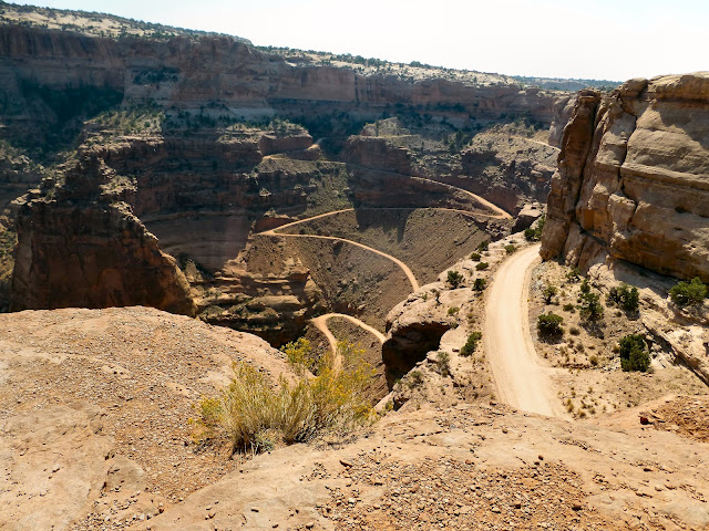
Canyonlands National ParkThe Island in the Sky section of Canyonlands is a massive mesa that sits two giant steps above the Green and Colorado Rivers. The White Rim, which sits 1200 feet below the mesa, has been intricately eroded another 1000 feet by the rivers. The White Rim Road, visible from many of the overlooks, makes a complete circuit of the rim that takes a minimum of two days by off-road vehicle.
 |
| Shafer Trail to White Rim Road |
 |
| Green River at Canyonlands |
Due to the smoke accumulation in The Needles section of the park, we decided not to visit and The Maze section of the park is one the most inaccessible places in the United States and we never had any intention of visiting there.
-----------------------------------
Capitol Reef National ParkThe primary purpose of this park is to protect the Waterpocket Fold, a monocline, described as a major wrinkle in the earth. It's quite dramatic when viewed from the ground, but with a length of a hundred miles, only aerial views show how impressive it truly is. The National Park Service should provide airplane rides, but only provides photographs.
Early American explorers thought that the white domes of the area resembled the U.S. Capitol Building and that the Waterpocket Fold acted like a barrier reef to their wagons, thus giving us the name for Capitol Reef National Park.
 |
| Capitol Dome behind Waterpocket Fold |
------------------
Other ThingsMoab, UT
Moab may be a funky mountain town but it is easily the most cosmopolitan place in Utah. Every shop and restaurant was filled with people speaking German, French and Italian and they certainly outnumbered the American tourists.
Utah Highway 24
With Moab as our base, we entered Capitol Reef National Park from the east side by way of Highway 24 from Hanksville. As we drove down the road, the terrain became so strange and so different from anything I had ever seen before that I began to think I might actually be driving on a highway on some distant planet. I took photographs during the return trip (see link below) and these give some idea of what I mean, but the back trail was just different enough that it lost a little bit of that other-worldly flavor
The Wasatch Range
Fall comes early in the Wasatch Range. The Canyon Maple were full red as we drove Utah 6 , but, again, the smoke really made it far less enjoyable than it might have been.
For Additional Photos, click below:

